The weather in Southern New England will stay cool for, at least, the next week, with the best chance for temperatures in the mid to upper 40s coming during a storm that transitions from snow to rain on Tuesday. Sunday will be mostly sunny, breezy, and cool. Highs will be near 40 – roughly 10 degrees below normal. The wind will diminish Sunday night, and the temperature will drop into the upper teens to mid 20s by dawn under clear skies.
Monday will be bright and chilly through midday before clouds roll in during the afternoon. The high temperature on Monday will not reach 40° in most spots. Look for about 34-38° in most of Southern New England. A storm over the Great Lakes will be transferring its energy to a developing system over the Mid-Atlantic by Monday night. There will be a “front end thump” of wintry precipitation in Southern New England late Monday night as the storm arrives. There should be enough cold air in place for snow to fall in nearly all of RI, MA, and CT Monday night.
The snow accumulation forecast with this system is very tricky because of the time of year and nocturnal timing of the snow. The wind will be out of the east, and a quick change to rain may occur in Eastern MA and at the RI coast. Farther inland, the cold air should hang on for several hours. Night is the most favorable time for snow accumulations in mid-March because of the high sun angle during the day. Even though it’s been chilly, the ground is not completely frozen in the I-95 corridor. Pre-treated surfaces will most likely not see significant accumulating snow. Some side roads, driveways, and sidewalks will be covered with snow. The most snow accumulation will be on the grass, cars, etc.
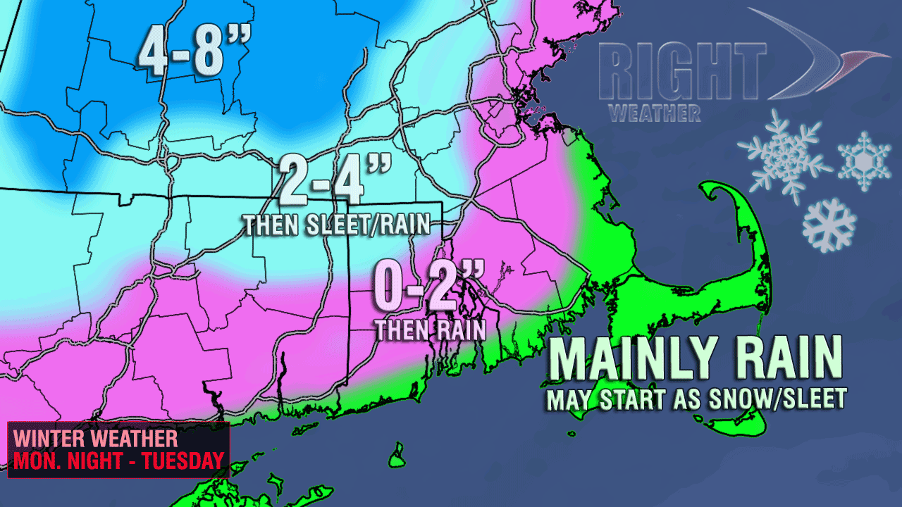
As the storm gets closer, a change to chilly rain is likely from the coast to inland locations. The change will occur at the coast before there is any appreciable accumulation. In the I-95 corridor, there may be a couple of inches of snow before a change to chilly rain. Farther inland, especially in the high elevations, a few inches of snow may accumulate. The Tuesday morning commute may be snowy inland (NW RI, NE CT, Worcester County), and will most likely be rainy in the rest of Southeastern New England. The rain that follows the snow may be heavy at times Tuesday morning before winding down in the afternoon. The temperature will reach the mid to upper 30s well inland, and low to mid 40s near the coast.
The weather following the storm will be similar to what has been common so far in March – breezy, chilly, and dry – with highs in the upper 30s to low 40s. Spring arrives Wednesday at 7:02 am, but it may be a while before Southern New Englanders get to enjoy any spring-like weather.