
The degree of difficulty with the weekend forecast is a lot higher than it was a week ago just prior to the blizzard. In that case, we were fairly certain of more than a foot of snow, and we knew of the strong potential for more than two feet in some locations. This time around, the forecast is a lot more challenging because the storm that will form in the Atlantic Ocean is not being handled well by all the computer models, and, even at this late stage of the game, they are showing a variety of solutions for Southeastern New England. Most models agree on a significant storm forming in the Atlantic along a Arctic front that will get offshore tonight. The uncertainty revolves around the exact track that storm takes as it moves north-northeast toward the Canadian Maritimes.
One of the things that makes this forecast so difficult is the relative impact difference between 1″ and 6″. Obviously, 1″ is of no concern, but a 6″ snow event is enough to slow travel and alter some plans. Aside from a foot, there’s not a huge difference in terms of impact between 12″ and 24″!
Below are the snow odds graphics that Right Weather has been using all winter to help you get an idea of the degree of confidence in a forecast, and the most likely range of totals in the Providence area. At the bottom of the post is the more traditional accumulation map.
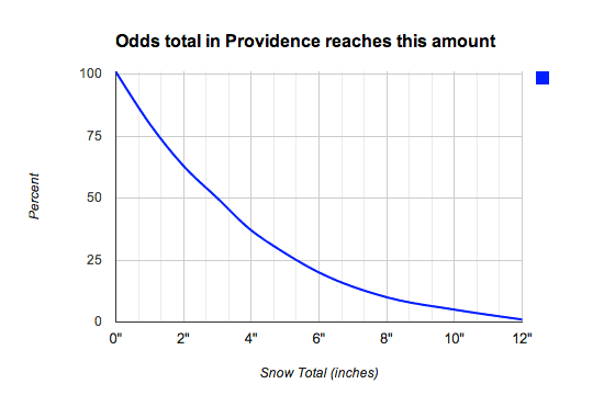
The first graphic shows the percent odds (left axis) that the snow total in the Providence area this weekend reaches a certain amount (bottom axis) in inches. As you can see, it’s not even a lock that Providence will receive 1″ of snow, but the odds of it happening are rather high. The 75% threshold occurs at about 1.5″, and the 50/50 crossover is at roughly 3″. The 25% threshold is just shy of 6″. Notice how the door is open, albeit slightly, for higher amounts all the way up to 12″. That would be in a worst-case scenario where the storm travels about 50-75 miles farther west than currently forecast. In many other storms this winter, the odds of getting more than 6″ were nil.
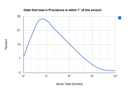
The second graphic displays the odds of the final total being within 1″ of the amount displayed along the bottom axis when you follow the blue line. The odds are highest that the final total will be within 1″ of about 2.5″, but, once again there are reasonable odds of much more or less. There is a possibility (roughly 10%) that the final total is less than 1″, and there are roughly the same odds that the final total is between 6-8″. Notice how, once again, the door is open for higher amounts if the potent storm comes closer than currently forecast.
Below is the traditional accumulation map. Since a 1-7″ map usually doesn’t go over too big, we try to narrow the focus to the most likely amounts. Notice how there is potential for more in SE MA based on the proximity to the storm’s center. Keep in mind, all of these forecasts encompass the snow totals from late Friday night through Sunday afternoon.


