There is little doubt that the eastern half of the United States is heading for a very chilly first half of March. Maybe, by the luck of the Irish, the pattern will break by St. Patrick’s Day. Overall, the spring breakers in Florida are not going to be too excited about the much cooler than normal weather. In the Northeast, the pattern will be cool, and it will mostly be felt during the day. Most of the time there will be a decent pressure gradient between high pressure to our west and offshore storms. As a result, we’ll see a northerly breeze most of the time for the first 10 days of March. The breeze, combined with some clouds, will keep it cool during the day, but the overnight low temperatures will not be brutally cold for the same reasons – the clouds/breeze actually keep the temperature up a bit at night.
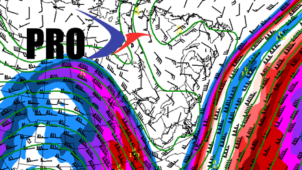
The x-factor is whether any big storms will develop close enough to the Eastern Seaboard to have an impact after the mid to late week storm this week. Right now, it looks like the answer is no, but it’s a very low confidence forecast given the weather pattern. It would not be a surprise to see something spin up off the Eastern Seaboard and have an impact in the Northeast during the first 10 days of the month.


