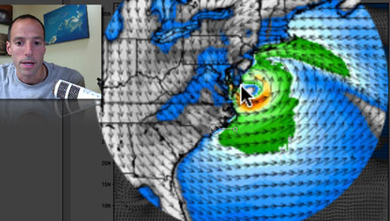
People living in the Northeast from Virginia to Maine should be making preparations for Hurricane Sandy. The storm is forecast to move inland somewhere between the Chesapeake Bay and Long Island Monday night or early Tuesday. Sandy, although, a minimal hurricane as of 2pm Friday, is likely to strengthen some in the next 48 hours before reaching the coast as a hurricane. The storm is taking a unique path to the coast that is different than Hurricane Irene in 2011. Right Weather Meteorologist Fred Campagna has the latest on Friday’s computer model runs and the potential impact in Southern New England from Hurricane Sandy.
Become a Right Weather Pro subscriber for access to the Live Blog this weekend and during the storm.
Visit the Hurricane Preparation page
Follow Sandy with the Interactive Hurricane Tracker
Interactive Radar and Buoy Observations


