As of 8 pm Tuesday, Sandy was 225 miles south of Kingston, Jamaica with maximum sustained winds of 50 mph. The central pressure of the storm was 991 mb, down from 993 mb earlier in the day. The storm was starting to strengthen. The official National Hurricane Center forecast strengthens Sandy to a Category 1 hurricane when it hits Jamaica around midday Wednesday. The storm continues moving nearly due north and hits Cuba as a hurricane before weakening to a tropical storm when it reenters open water south of the Bahamas. It continues north on Friday through the Bahamas, not far from Nassau, as a strong tropical storm with sustained winds of 70 mph.

The National Hurricane Center forecast then turns the storm to the northeast over the weekend, and it also transitions the storm from tropical to post-tropical as it encounters the jet stream and heads in the direction of Bermuda. Of course, the National Hurricane Center uses a five day forecast, so there is no way to know exactly what they are thinking in the 6-9 day timeframe when the storm may impact New England. Fortunately, we can look to another government agency to get an idea of what the National Hurricane Center, and the bright meteorologists at the National Weather Service Hydrometeorological Prediction Center are projecting for Sandy (or the storm that used to be Sandy) in the longer run. The 3-7 day forecast below clearly favors the ECMWF model track with a tropical system transitioning to an extratropical storm and hitting Long Island or Southern New England. One curious aspect to this, is the relatively high pressure of the storm on day 7 as it hits the coast. 988 mb is a decent storm, and maybe they are playing it cautiously for now, but I haven’t seen many models that bring the storm back to the coast forecasting anything close to 988 mb. As you read in the model roundups, most of the models are somewhere between the 930s and the 960s when near the Northeast coast. I think 970-something is probably more realistic than 988 mb.

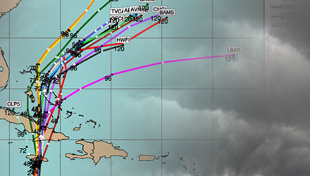
Hurricane Models
The newest hurricane models are a bit farther northwest with Sandy as it leaves the Bahamas. They all take a turn to the east, but you’ll notice at 120 hours (the end of the lines) that several of the tracks are starting to turn to the north. This is not particularly encouraging news if you’re looking for a storm that has no impact in the Northeast.

The intensity guidance has not changed much from earlier today. Most of the models have the storm as a strong tropical storm or category 1 hurricane between 24-120 hours. That makes the ECMWF model seem out to lunch with its forecast of a 953 mb storm at 108 hours. 953 mb typically corresponds to a category 3 storm.

The Bottom Line

While Tropical Storm Sandy bears watching as a potentially major storm (and headache) for the Northeastern United States, there is still plenty of time to prepare, and for the forecast to change drastically. If some of the more dire scenarios pan out, we’ll be telling our grandkids about this storm. If the storm manages to stay offshore and never impacts us, we’ll be telling our grandkids about all the hype surrounding the storm that never was. I think I’ve made it pretty clear that the forecast is uncertain for the storm, and I don’t want anyone to think that we are trying to hype it up. That is not our M.O.. As new information comes in, we’ll be sure to dissect and disseminate as quickly as we can over the next several days. We strive for a certain level of transparency with our forecast process, so you will see posts, Tweets, and Facebook updates that touch on what the computer models are indicating. Keep in mind, that a computer model simulation is not a Right Weather forecast.
So, you may ask, what is the Right Weather forecast for this storm? If I knew for certain, I’d be trumpeting it from the housetops and hilltops. At this point, since you’re pinning me down, I think we’ll see a strong tropical storm or minor hurricane emerge from the Bahamas, maintain an intensity between 60-80 mph as it moves over the Gulf Stream, start to head northeast toward Bermuda, then turn to the north, and eventually northwest. That doesn’t necessarily answer the question of will it directly hit New England. I think there’s a good chance it does, but I think there’s a slightly better chance it ultimately makes landfall in Nova Scotia. Here is how I rank the scenarios with 1. being the most likely.
1. Hits Nova Scotia, strong Nor’easter for Eastern New England. Beach erosion, howling winds (30-60 mph), some heavy rain bands.
2. Major storm hitting Southern New England or Long Island. Near hurricane force winds, heavy rain, damaging storm surge, coastal flooding, beach erosion.
3. Storm heads out to sea with little to no impact for Eastern United States. The ridge over the North Atlantic is going to be the dominant factor with the track of this storm. If you’re a Patriots fan it’s Vince Wilfork and the storm is some 200 lb running back trying to get through the line. Odds are, unless he is really shifty, he’s not making it through Big Vince. If the storm does make it out to sea, it will probably do so early in the game, which means we’ll know it’s going to happen by Thu/Fri. If, by that time, we’re still seeing computer model runs that consistently bring the storm our way, then it’s most likely coming our way!
As always, we’ll keep you posted. Download the FREE RightWX App for your iPhone, iPad or Android device. All these updates, minus some graphics, will be available on the App.


